Inertial sensors can provide a wealth of orientation, position, and timing information for independently operating machines. The need to extract reliable inertial data in unmanned and remote applications continues to demand more precise and autonomous sensors. In a project with the Quad Cities Collaboration (QC Co-Lab) and Hackerspace Laboratory, MicroStrain’s miniature inertial sensor was used to demonstrate real-time wireless monitoring of a lightweight kite during flight. The solution captured and communicated continuous acceleration, angular rate, magnetic field, and GPS location without impacting flight performance. Furthermore, the flexible system supported the development of a custom graphic interface. The development of smaller, more costeffective inertial sensors promotes their adoption in a growing number of fields with an emphasis on integrating high performance sensors in everyday applications.
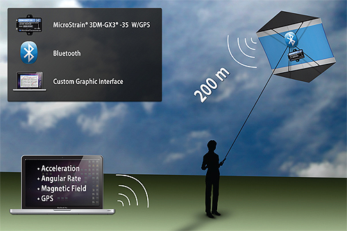
Microstrain’s 3DM-GX3-35 with GPS communicated orientation and positioning data over 200 meters to a custom interface.
The QC Co-Lab and Hamilton Technical College set out to perform low altitude flight tests during Iowa’s Quad Cities Kite Festival. The project objective was to generate a remote display of a kite’s orientation and location using only wireless inertial and GPS sensors. Lift limitations restricted the incorporation of additional weight. As a result, sensor profile and weight were a primary consideration.
The project team selected the MicroStrain 3DM-GX3-35 inertial sensing suite with embedded GPS capabilities. The unit is one of the smallest, lightest Attitude Heading Reference System (AHRS) with GPS available. Each device is individually calibrated for temperature, sensitivity, and sensor misalignment. Each inertia unit is enclosed in a rugged aluminum case and weighs less than 50g. Because of its miniature, lightweight design the project was able to incorporate inertial sensing capabilities with minimal impact on the weight and weight distribution of the kite body. Low energy consumption capabilities reduced both the weight and size of external batteries. The RS-232 communication interface supported a GPS antenna and Bluetooth connectivity for wireless data transmission.
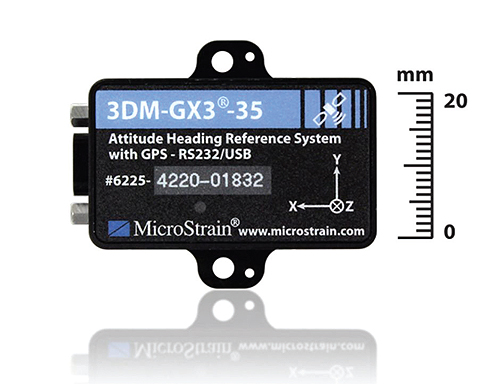
The high performance miniature Attitude Heading Reference System (AHRS) with GPS, combines MEMS sensor technology and a sensitive embedded GPS receiver.
The result successfully monitored tri-axial acceleration, angular rate, magnetic field, and altitude from a distance of more than 200 meters. Visual representations of kite orientation and rotation were displayed in real-time using the QC Co-Lab’s custom interface developed with C++ and Linux. In addition, the ground portal contained a text window to convey live GPS, roll, pitch, and yaw data streams. Customizable data outputs enabled the project to adjust and optimize monitoring rates for extended battery life and kite deployment.
Microstrain
www.microstrain.com
::Design World::
Filed Under: SENSORS, TEST & MEASUREMENT




Tell Us What You Think!