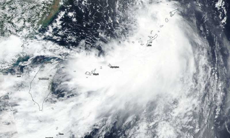
On Aug. 15, 2018, NASA-NOAA’s Suomi NPP satellite flew over newly formed Tropical Depression Rumbia. (Image Credit: NASA/NOAA Worldview)
Tropical Depression Rumbia, the twenty-first tropical cyclone of the Northwestern Pacific Ocean season formed on Aug. 15, as NASA-NOAA’s Suomi NPP satellite flew overhead.
The Visible Infrared Imaging Radiometer Suite (VIIRS) instrument aboard NASA-NOAA’s Suomi NPP satellite captured a visible image of Rumbia that showed a large storm over Japan’s southern islands. The storm was moving toward the East China Sea. The Joint Typhoon Warning Center noted that satellite imagery shows a broad low level circulation with extensive deep convection along the eastern and southern peripheries and more limited convection near the center.
On Aug. 15 at 5 a.m. EDT (0900 UTC), the Joint Typhoon Warning Center (JTWC) reported the center of Rumbia was located near latitude 28.5 degrees north and longitude 126.6 degrees east. That’s about 107 nautical miles north-northwest of Kadena Air Base, Okinawa Island, Japan. The tropical depression was moving toward the north-northwest. Maximum sustained winds were near 34.5 mph (30 knots/55.5 kph).
Rumbia is expected to briefly become a tropical storm before weakening and making landfall near Shanghai, China on Aug. 16.
Filed Under: Aerospace + defense


