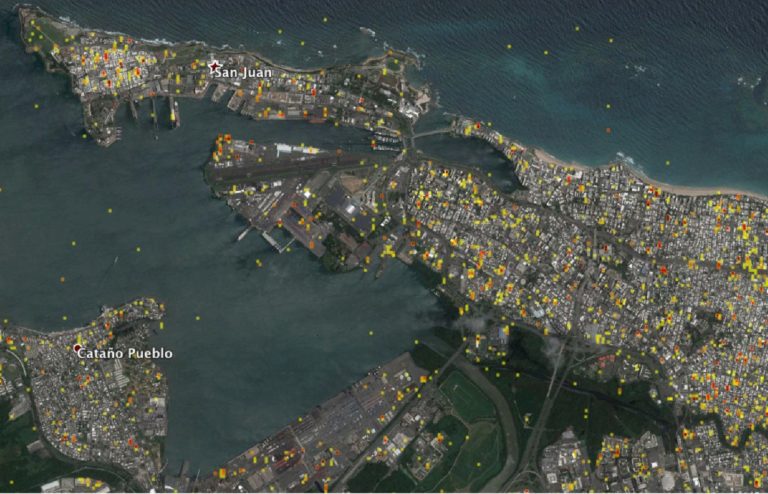
NASA’s Disasters Program has delivered to the Federal Emergency Management Agency (FEMA) a map of areas in eastern Puerto Rico that have likely been damaged as the result of the landfall of Hurricane Maria on Sept. 20.
The “damage proxy map” was created by the Advanced Rapid Imaging and Analysis team at NASA’s Jet Propulsion Laboratory in Pasadena, California, and Caltech, The map is derived from synthetic aperture radar images from the Copernicus Sentinel-1A and Sentinel-1B satellites, operated by the European Space Agency. The images were taken before and after the storm’s landfall. The map was delivered to responding agencies, including FEMA, which combined the map with building infrastructure data to estimate a damage density map. This information was sent to FEMA’s Urban Search and Rescue teams in the field in Puerto Rico.
The full map covers an area of 105 by 60 miles, with an inset showing the extent of damage in and around the capital city of San Juan. Each pixel in this image measures about 98 feet across. The color variation from yellow to red indicates increasingly more significant ground surface change. This damage proxy map can be used as guidance to identify damaged areas.
The NASA Disasters Program, part of the Earth Science Division in the Science Mission Directorate, works with international, regional, and local disaster management agencies to provide critical information using global environmental data from NASA’s fleet of Earth science satellites and other airborne and space-based assets. Dedicated teams of Earth-observation disaster specialists at NASA centers mobilize to assist in preparations for, responses to, and recovery from a wide range of natural and human-made hazards.
Click here for more information and to download the high-resolution image.

(Image Credit: NASA)
Filed Under: Aerospace + defense


