Design World

  • Home
  • Technologies
    • 3D CAD
    • Electronics • electrical
    • Fastening & Joining
    • Factory automation
    • Linear Motion
    • Motion Control
    • Test & Measurement
    • Sensors
    • Fluid power
  • Learn
    • Ebooks / Tech Tips
    • Engineering Week
    • Future of Design Engineering
    • MC² Motion Control Classrooms
    • Podcasts
    • Videos
    • Webinars
  • LEAP AWARDS
  • Leadership
    • 2022 Voting
    • 2021 Winners
  • Design Guide Library
  • Resources
    • 3D Cad Models
      • PARTsolutions
      • TraceParts
    • Digital Issues
      • Design World
      • EE World
    • Women in Engineering
  • Supplier Listings

Satellites Map Fire On Saddleworth Moor

By United Kingdom Space Agency | June 29, 2018

Share

The U.K. Space Agency has worked with partners to activate the Copernicus Emergency Management Service to provide satellite mapping to aid the response to fires burning on Saddleworth Moor, Greater Manchester.

U.K. satellite imagery was also provided to government officials co-ordinating the response to help provide initial estimates of the scale of the blaze. The images below shows initial estimates of burned area and is taken from Airbus U.K.-DMC2 satellite imagery acquired early on Wed 27th June.

Sara Huntingdon from the U.K. Space Agency said, “The U.K. space sector plays a major role in using satellites for disaster risk management including the International Disaster Charter which brings together a collection of satellites from all over the world to collect data and images from areas suffering from natural and man-made disasters. From the Caribbean to the moorlands of Manchester, satellite data can play a major role in helping first responders coordinate relief efforts and potentially save lives.”

In a further demonstration of the U.K.’s expertise in this area, U.K. scientists at the University of Bristol recently made a major contribution to assessing the hazard of Guatemala’s Fuego volcano. Maps and scientific analysis from satellite imagery including the Charter were provided to Guatemalan civil protection and local volcanologists.

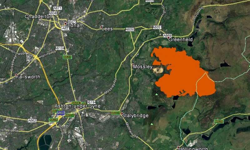
Initial delineation map of the burn area. (Image Credit: Airbus DS 2018, Google)

The Charter is made up of 16 agencies, including the U.K. Space Agency, who work in partnership with Airbus to provide images and other satellite information free of charge to emergency response agencies around the world, whenever major disasters strike.

Since the Charter was founded in 1999 it has responded to 576 disasters including tsunami in Indonesia and Thailand in 2004, the Deepwater Horizon oil spill in the Gulf of Mexico in 2010, the earthquake in Nepal in 2015 and Hurricane Irma last year in the Caribbean.


Filed Under: Aerospace + defense


Related Articles Read More >

Ontic acquires Servotek and Westcon product lines from Marsh Bellofram
Flexible rotary shafts support thrust reverser on 150 LEAP 1-A turbofan engines
Drone-mounted inspection breaks barriers for F-35
TriStar, a misunderstood failure of design

DESIGN GUIDE LIBRARY

“motion

Enews Sign Up

Motion Control Classroom

Design World Digital Edition

cover

Browse the most current issue of Design World and back issues in an easy to use high quality format. Clip, share and download with the leading design engineering magazine today.

EDABoard the Forum for Electronics

Top global problem solving EE forum covering Microcontrollers, DSP, Networking, Analog and Digital Design, RF, Power Electronics, PCB Routing and much more

EDABoard: Forum for electronics

Sponsored Content

  • Global supply needs drive increased manufacturing footprint development
  • How to Increase Rotational Capacity for a Retaining Ring
  • Cordis high resolution electronic proportional pressure controls
  • WAGO’s custom designed interface wiring system making industrial applications easier
  • 10 Reasons to Specify Valve Manifolds
  • Case study: How a 3D-printed tool saved thousands of hours and dollars

Design World Podcasts

May 17, 2022
Another view on additive and the aerospace industry
See More >
Engineering Exchange

The Engineering Exchange is a global educational networking community for engineers.

Connect, share, and learn today »

Design World
  • Advertising
  • About us
  • Contact
  • Manage your Design World Subscription
  • Subscribe
  • Design World Digital Network
  • Engineering White Papers
  • LEAP AWARDS

Copyright © 2022 WTWH Media LLC. All Rights Reserved. The material on this site may not be reproduced, distributed, transmitted, cached or otherwise used, except with the prior written permission of WTWH Media
Privacy Policy | Advertising | About Us

Search Design World

  • Home
  • Technologies
    • 3D CAD
    • Electronics • electrical
    • Fastening & Joining
    • Factory automation
    • Linear Motion
    • Motion Control
    • Test & Measurement
    • Sensors
    • Fluid power
  • Learn
    • Ebooks / Tech Tips
    • Engineering Week
    • Future of Design Engineering
    • MC² Motion Control Classrooms
    • Podcasts
    • Videos
    • Webinars
  • LEAP AWARDS
  • Leadership
    • 2022 Voting
    • 2021 Winners
  • Design Guide Library
  • Resources
    • 3D Cad Models
      • PARTsolutions
      • TraceParts
    • Digital Issues
      • Design World
      • EE World
    • Women in Engineering
  • Supplier Listings