The following images were taken by astronauts on board the International Space Station. This Top 15 list was selected by NASA Johnson Space Center’s Earth Observations team.
1. Lake Chad and a Bodele Dust Plume, Sahara
Expedition 42: 02 February, 2015
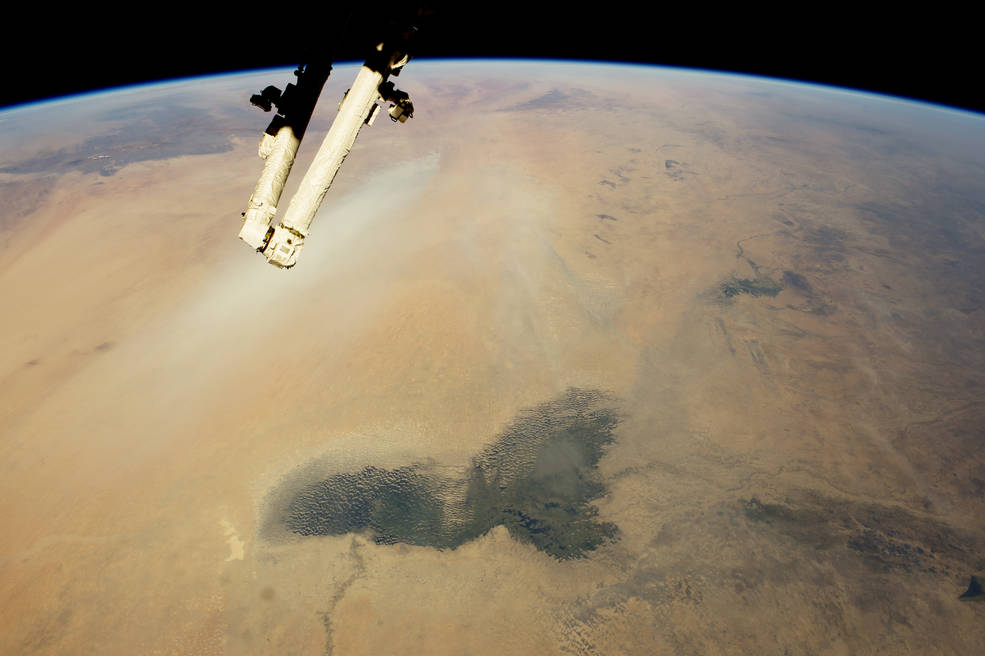
All image credit: NASA
The arid landscapes of the Sahara and the darker vegetation of the wetter, semi-arid woodland known as the Sahel…
The dark green marshes of Lake Chad stand out in the foreground. Even though it is more than 200 kilometers (120 miles) long, modern Lake Chad is just a small remnant of a vast lake that has repeatedly occupied the most of this landscape in the recent geological past. This lake basin stretches almost 1000 kilometers (600 miles) from the foreground of the image to the foot of the Tibesti Mountains…. Read More
2. Volcanoes, Vog, and Vortices, Hawaii
Expedition 42: 8 February, 2015
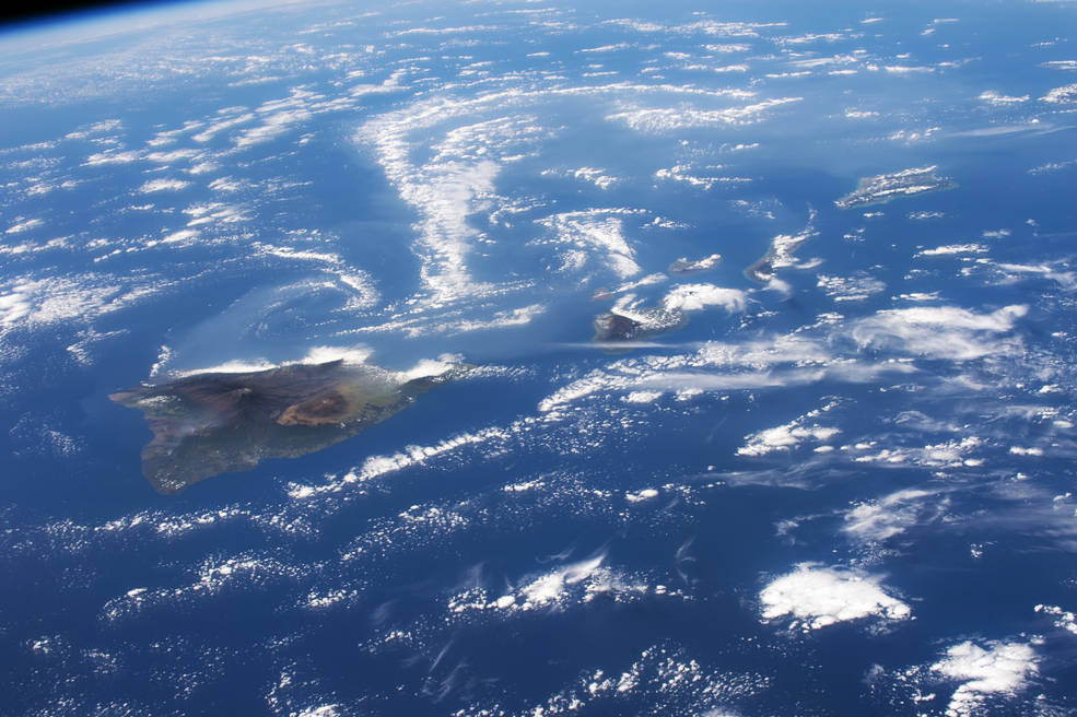
Hawaii’s Kilauea volcano (image left) with the long swirls of volcanic gases (top half of the image) wafting west from the volcano…
Astronauts are trained to take oblique images of hard-to-see atmospheric haze by shooting obliquely to enhance visibility. The gas haze—termed vog, a combination of fog, smog and volcanic—is well known in Hawaii, and is defined as “a form of air pollution that results when sulfur dioxide and other gases … emitted by an erupting volcano react with oxygen and moisture in the presence of sunlight….” Read More
3. Sierra Nevada de Santa Marta, northern Columbia
Expedition 42: 27 February, 2015
A dramatic view of the many peaks of Colombia’s Santa Marta massif…
The highest of these (approximately 5700 m, 18,700 feet), named for Christopher Columbus, is so high that it supports a small but permanent snow cap (image far left), even though it lies only ten degrees north of the Equator. The summits are so high that trees cannot grow—landscapes appear gray because only grass and small shrubs can survive the cold…. Read More
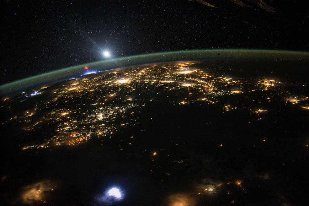
4. Scandinavia at Night
Expedition 43: 3 April, 2015
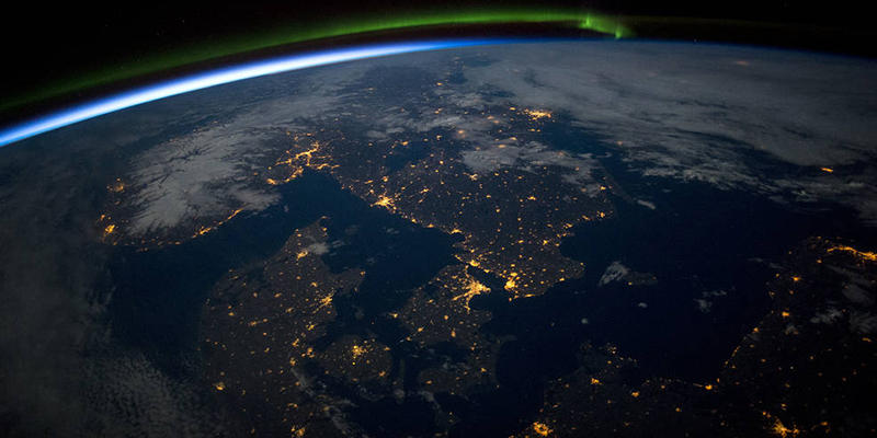
Southern Scandinavia just before midnight under a full moon…
Prominent features include a green aurora to the north (upper middle of the image), the blackness of the Baltic Sea (lower right), clouds (top right) and snow in Norway illuminated under a full moon. City lights clearly show the recognizable coastline of the Skagerrak and Kattegat seaway leading into the Baltic Sea that separates Denmark from its neighbors to the north…. Read More
5. Good Air and Brown Water, Argentina
Expedition 43: 6 April, 2015
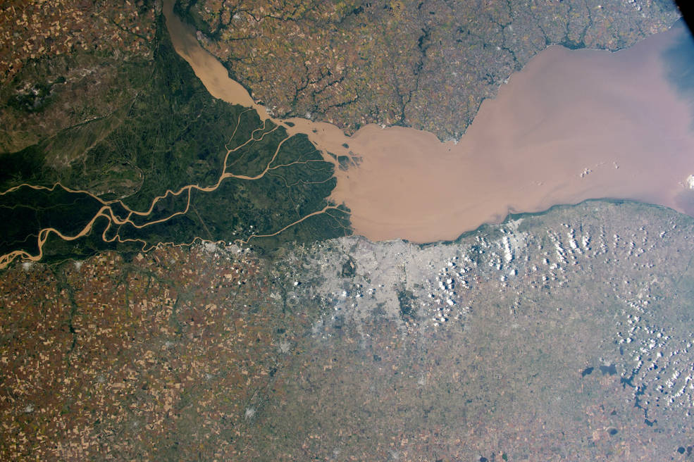
The eye-catching delta and green swamps of the Paraná River (image left) on the Atlantic coast of Argentina…
The Paraná River, South America’s second largest after the Amazon River, pours brown muddy water into a wide estuary known as the River Plate (image center and right). The gray mass of Argentina’s capital city, Buenos Aires (metro population 12.74 million in 2010), is less prominent seen from space (upper left), although astronauts quickly attune their eyes to the subtle signature of such cityscapes…. Read More
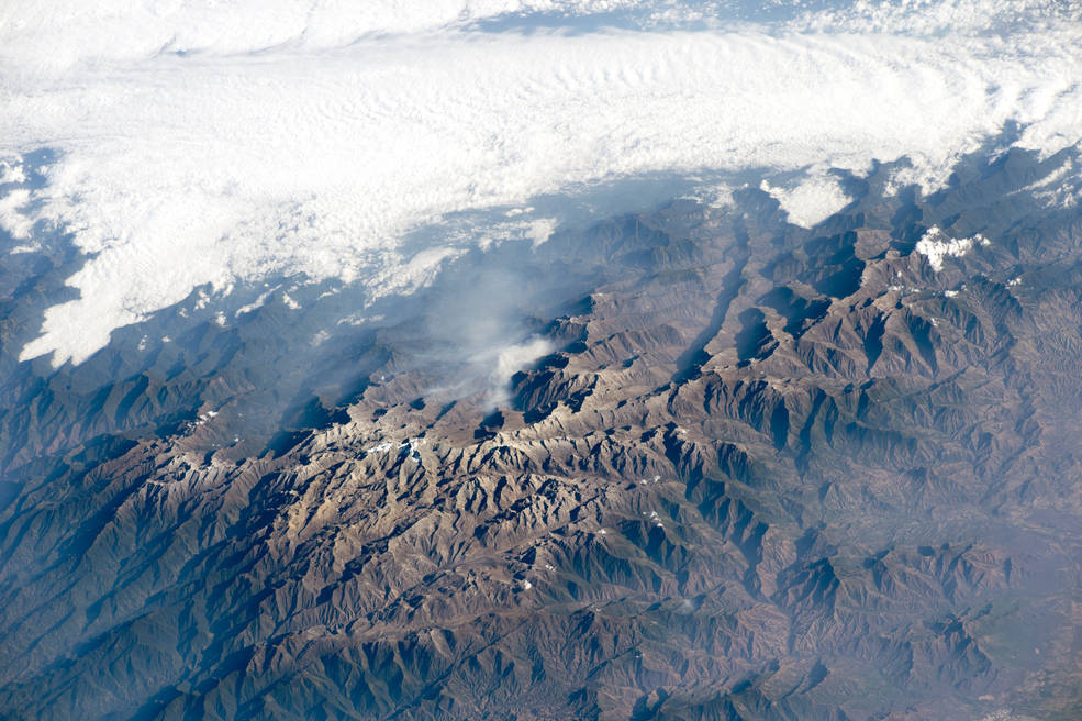
6. Rivers and Snow in the Himalayas, China and India
Expedition 43: 8 April, 2015
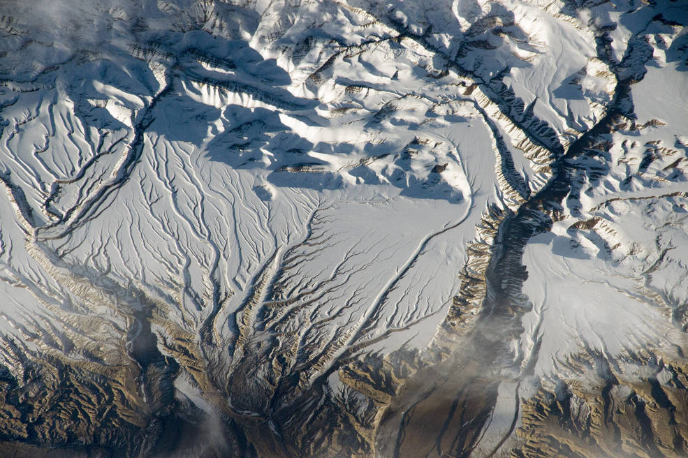
The Himalaya range, near the China–India border…. where peaks cast strong evening shadows on the snow…
For millions of years, water has eroded rock from these high mountains and deposited the sediment in ancient, broad alluvial fans. Snow cover highlights these strikingly smooth surfaces, while a trellis-like network of gullies cuts through and casts sinuous shadows. The largest river in the scene has cut a 500-meter-deep (1,650 foot) canyon (right)…. Read More
7. Laguna Colorada, Bolivia
Expedition 43: 16 April, 2015
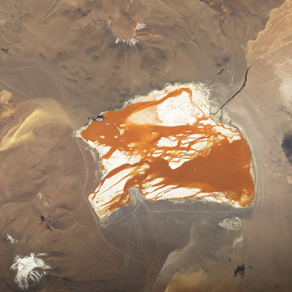
The brightly colored Laguna Colorada, unique in this part of the Bolivian Andes Mountains…
The lack of atmospheric haze at great altitude—the lake lies at 4300 m above sea level (14,100 feet)—helps make images of the region especially clear. The strong red-brown color of this shallow, 10 km-long lake is derived from algae that thrive in its salty water. But the lake occasionally has green phases because different algae display different colors, the type being determined by the changing salinity and temperature of the water…. Read More
8. Adele Island, northwest Australia
Expedition 44: 11 June 2015
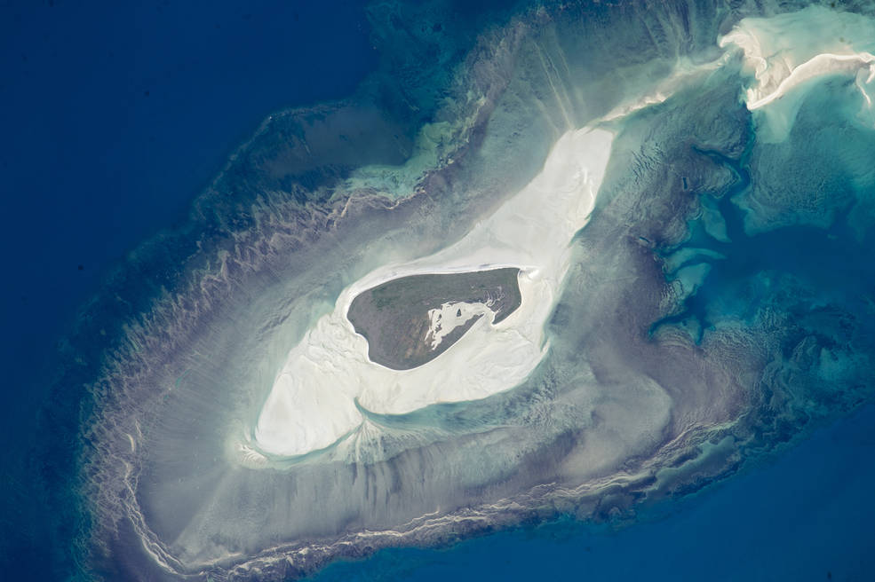
A tiny island with many concentric zones around it. Adele Island, off Australia’s north coast…
The modern island is the dark central area, made up of a series of beach ridges built by sands from the surrounding sandbank during storms. The highest point is little more than 12 feet above sea level on this grassy but treeless island. A solar-powered lighthouse appears as a tiny white dot in the high-resolution image at the north tip of the island (arrowed). The island has been classified as an Important Bird Area because it is a breeding site of world importance for Lesser Frigatebirds and three other species…. Read More
9. Salt Ponds, western Australia
Expedition 44: 11 June, 2015
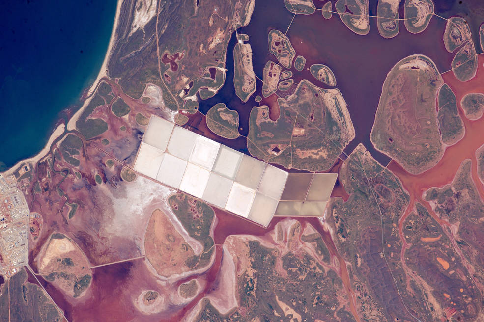
Coastal lagoons with numerous rounded islands are typical of the Indian Ocean coastline of Western Australia…
These shapes contrast with the angular, white ponds of the salt extraction industry. Muddy red-brown inland water (image right and lower left) from recent rains is prevented by low causeways from mixing with darker (clearer) water nearer the coast…. Read More
10. Shaping Cape Cod, Massachusetts
Expedition 44: 13 June, 2015
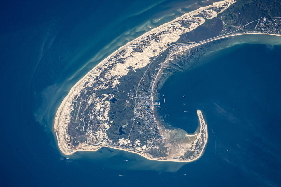
The northern tip of Cape Cod—showing 8.5 miles (14 km) of its 65-mile (105 km) length…
In terms of geological age, Cape Cod is young, having been laid down about 20,000 years ago by glaciers when these were at their fullest extent. Even though Cape Cod today has water on both sides, it consists of moraine and associated river deposits laid down by two large lobes of ice that extended into the area from Canada (i.e, out of the image upper left). Strange as it seems today, one great ice lobe lay to the seaward side of the cape, and another on the Cape Cod Bay side. Many ponds (image center) remain on Cape Cod as a result of the receding glacier (image center). Why is the cape shaped the way it is?…. Read More
11. The Port of Sfax, Tunisia
Expedition 44: 19 June, 2015
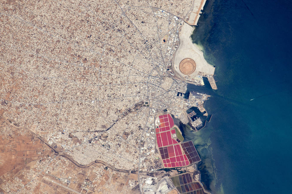
The radiating street pattern of Tunisia’s second city and major port of Sfax (population ~900,000), that also hosts Tunisia’s largest fishing fleet (for scale the fishing port is 1.1 km long)…
More detailed visual cues that tell astronauts they are overflying Sfax are the brilliantly colored salt ponds south of the old city and the new circular earth works of the Taparura redevelopment project just north of the old city. Named after the town in antiquity on which Sfax now stands, the redevelopment has reclaimed many hectares along 5 km of shoreline (extending outside the image) and reengineered a polluted and marshy area on the coastal side of the long curve of the city’s railroad tracks…. Read More
12. Flooding on the Mekong River floodplain, Thailand and Laos
Expedition 44: 8 August, 2015
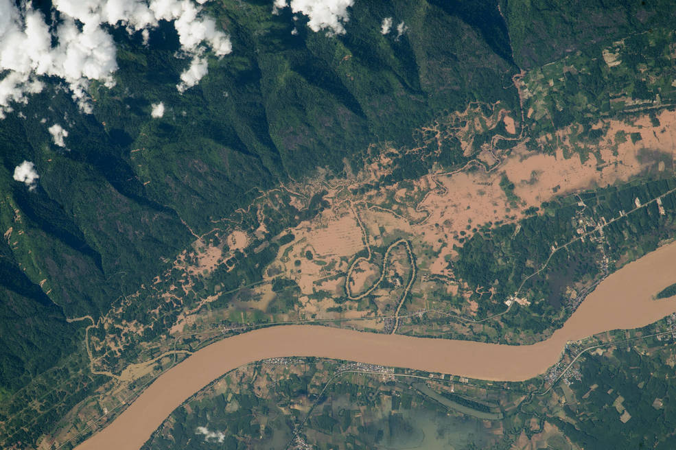
The Mekong River on the border between Thailand and Laos…
Southeast Asia’s largest river winds as a red-brown channel of floodwater resulting from very heavy monsoon rainfall that affected populations from North Vietnam through Thailand and Myanmar to India, starting on 26 July. ISS crews have been specially tasked to document floods photographically—-photos such as this represent the best of the kind imagery that NASA tries to gather to assist relief authorities on the ground…. Read More
13. Red Sprites, northwest Mexico
Expedition 44: 10 August, 2015
A red sprite above the white light of an active thunderstorm (image top left)…
Sprites are major electrical discharges, but they are not lightning in the usual sense. Instead, they are a cold plasma phenomenon without the extremely hot temperatures of lightning that we see underneath thunderstorms. Red sprites are more like the discharge of a fluorescent tube. Bursts of sprite energy are thought to occur during most large thunderstorm events…. Read More
14. Aquaculture, northeast China
Expedition 44: 6 September, 2015
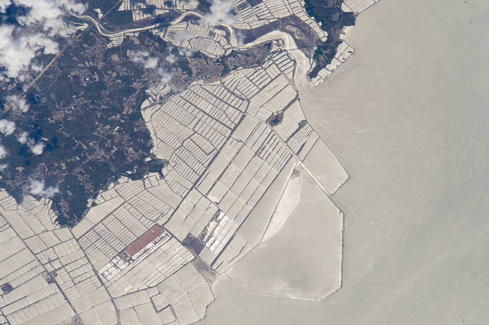
A grid pattern of fish farms on the coast of China’s northeast province of Liaoning…
The fish-farm basins have been built out from the dark-toned, wooded coast to a distance of nearly 6 km (4 mi)(image top left). Fish farms have been constructed at very many points along the province’s coastline, but this group of basins, facing the Yellow Sea, is the largest (Liaoning Province is the sixth in China in terms of aquaculture production)…. Read More
15. India-Pakistan Border at Night
Expedition 45: 23 September, 2015
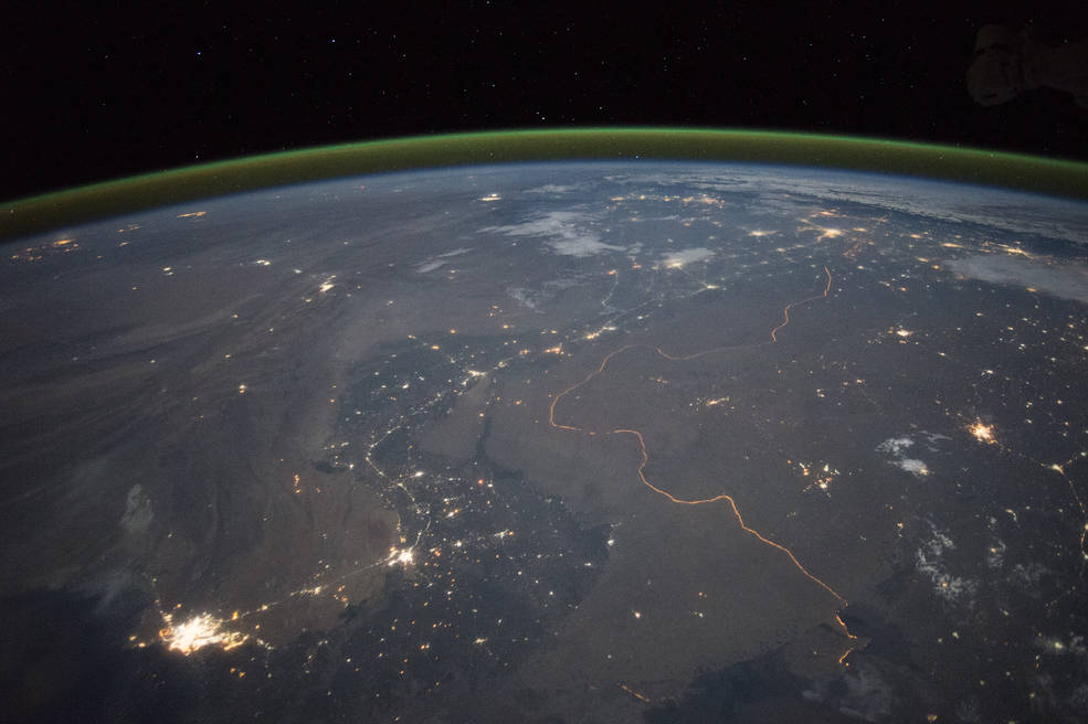
Nighttime panorama looking north across Pakistan’s Indus River valley…
This photograph shows one of the few places on Earth where an international boundary can be seen at night. The winding border between Pakistan and India is lit by security lights that have a distinct orange tone. Another night image (click here) shows the border zone looking southeast from the Himalaya. A daylight view shows the vegetated bends of the Indus Valley winding through the otherwise desert country…. Read More
Filed Under: Aerospace + defense


