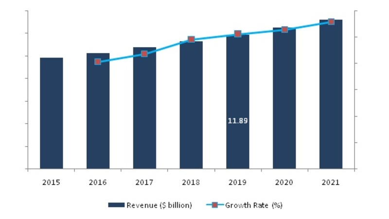
A recent report published by Market Research Future projects substantial growth in the global market for remote sensing. The market has steadily increased since 2016 due to adoption, and is expected to continue growing over the period focused on in the report (2016-2021). The projected growth in the remote sensor market is expected to reach ~5 percent CAGR during this stretch of time, which would surpass previous growth records set by the market.
(Image Credit: marketresearchfuture.com)
To clarify, remote sensing is the gathering of information about objects or areas from a distance. This is usually done via aircraft or satellite, where remote sensors can be mounted. Remote sensors collect data by detecting the energy reflected from Earth. Remote sensing satellites are usually launched into orbit so they can monitor and locate important human resources like animal migration, mineral deposits, or track deforestation rates.
It’s more effective to monitor these data types from space, since an orbiting satellite can photograph large expanses of land throughout the world. Since these satellites can photograph and observe areas on a global scale, these crafts can monitor parts of the planet with harsh climates or terrain that’s unreachable by land.
Important factors behind the spike in demand are growing investment on satellite communication, ISR payloads, along with increasing needs for advanced optical imaging systems (mainly for the functions mentioned above). In addition to these current uses, battlefield surveillance radar (BFSR), next-generation AmerHis Satellites, along with innovative advances in antenna and satellite technologies are current trends that will shape the remote sensing market between now and 2021. Some restraining factors the market has to look out for are costs for satellite launches, along with complexities attached to integrating remote sensing with different platforms.
Remote sensing satellites have a broad range of applications in different fields that are capable of supplementing this degree of projected growth. Coastal applications monitor shoreline changes, sediment transport, mapping coasts (and coastal features), along with preventing erosion. Ocean applications track sea ice, ocean circulation and current systems, temperatures and wave heights, and can help find better means of managing oceanic resources. Hazard assessments monitor natural disasters like hurricanes, earthquakes, floods, and erosion. This data can be used to evaluate natural disaster impacts and prepare better strategies before and after such occurrences. Natural resource management tracks land utilization, maps wetlands, charts wildlife habitats, and uses that data to mitigate damage from urban growth and decide how to best conserve natural resources.
In addition, remote sensing satellites will be useful for agricultural applications like estimating crop area and production monitoring droughts, mapping soil, analyzing crop systems, and even generating farming advisories in regions where it’s required. The growth will be slow and steady but as more industries recognize the value in this method of tracking and monitoring resources, more industries will continue utilizing its capabilities.
Filed Under: Aerospace + defense


